El Niño is here, but it hasn't bitten yet
The Bureau has declared El Niño active and says it could be the strongest on record. For croquet clubs, the useful news is in the fine print, not the headline.
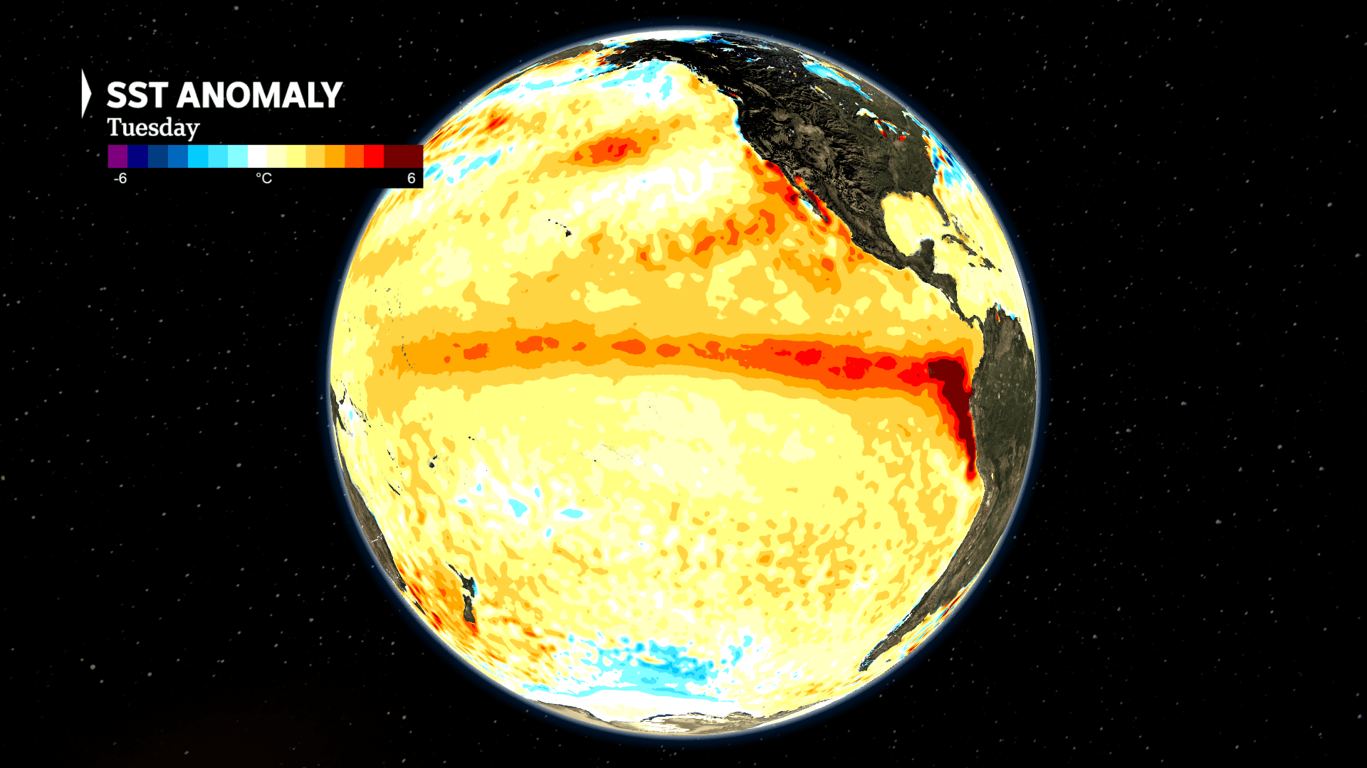
he Bureau of Meteorology declared El Niño on 16 June. The numbers behind the call are big. The Bureau's seasonal model has it peaking late in the year at more than 3°C above normal, which would beat the post-1900 high of 2.65°C set in November 1902.

The patch of tropical Pacific that forecasters watch has warmed faster this year than in any year since 1943. This is the seventh year running with either El Niño or La Niña. The last run that long was from 1969 to 1976.
For clubs, the big question is what this means for the lawns over the coming months.
A record El Niño does not mean a record drought.
An El Niño declaration is a reading of the ocean, and not much more. It tells us the central tropical Pacific has crossed a temperature line. What it does not tell us is how much rain will fall on your lawn.
Australia is surrounded by three oceans, and the Indian and Southern Oceans steer our weather as much as the Pacific does. Right now those other drivers are pushing the other way, towards rain, which is why much of the country has had soakings since early May.
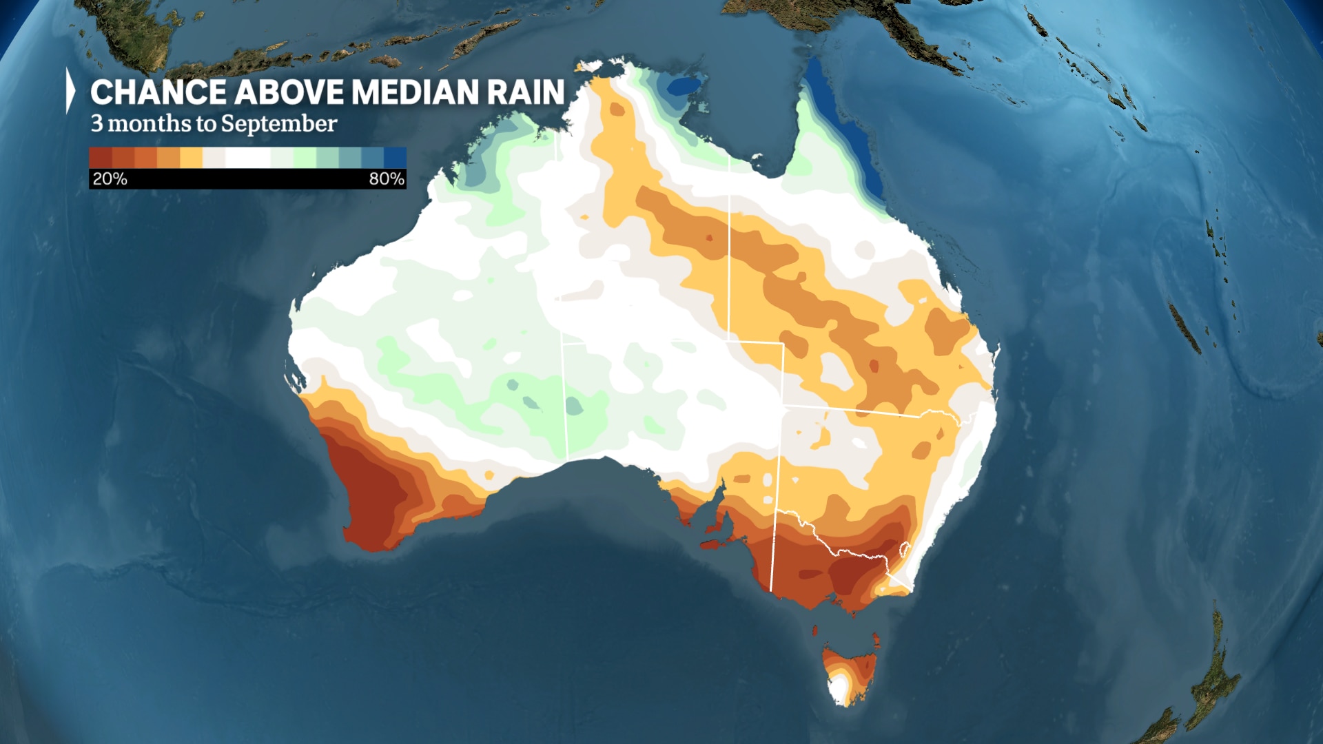
The Bureau's rainfall outlook for July to September leans dry across eastern Australia. (ABC News)
The Bureau's outlook for July to September leans dry across much of eastern Australia, but it only leans. A dry tilt in the odds still leaves plenty of room for rain.
Where El Niño bites harder is heat. Days are expected to run warmer in southern Australia through winter, spring and summer. Clear skies bring cooler winter nights and more frost, and a longer and harsher fire season is likely. Its effect on rainfall usually fades over summer, as it did during the last El Niño in 2023.
For a club, that means getting ready for a drier run into summer without betting the season on a drought that might not turn up.
The work itself is mostly unglamorous. On sandy soils, a wetting agent before a long dry spell helps the lawn actually take water in. Taking no more than a third of the blade height in any one cut takes the stress off the grass. And it pays to tighten the irrigation roster so it runs in the early morning, before 8am, instead of burning off at noon. Evening watering leaves the leaf wet overnight, which invites brown patch and other fungal diseases. None of this stops the dry. It does slow the damage.
The most useful thing any club can do is compare notes. A watering routine that carried one club's lawns through a dry spell is worth a lot to the club down the road, and what holds up in Brisbane might do nothing in Cairns. If yours has hit on something that works, the CAQ office wants to hear it, and so does the ClubHub thread The Coming Dry: What's your club's water plan?.
None of this is cause for panic. Do the basic lawn work, watch what the forecast actually says as winter goes on, and stay in touch with other clubs about what's holding up. A dry summer is far easier to manage when nobody is working it out on their own.
*Sea-surface temperature globe and rainfall outlook graphics: ABC News.*

Get HOOPLA! in your inbox

Windsor wins BNR Division 3 Pennant test against Toombul
Windsor secured a victory in the BNR Division 3 Pennant test against Toombul, with thanks to the team, supporters, and h…
Toombul crowned 2026 Brisbane North Region Champions
Toombul secured top spot in the Division 3 Pennants with four match wins, claiming the 2026 Brisbane North Region title …